
Replies sorted oldest to newest

OK. Let's get down to brass tacks. The US has a population of over 300 million. Canada has a population of 30 million in an area twice the size of the US. I'm going to take a wild stab at it here, but it's my guess that our ratio of traffic cops to km (or mile, take your pick) of road is going to be waaaay more favourable.

You see, while you Americans can only use your Pantera to crawl along in endless stop-and-go traffic jams at the Traffic Gestapo-enforced pedestrian speed limit in a vain attempt to impress the girls, us Canadians get to tear up some pavement and regularly drive our cars the way they were intended to be driven.

RMA_June_2006_-_incitement_on_a_sweeper

Attachments

Images (1)
  • RMA_June_2006_-_incitement_on_a_sweeper
Last edited by George P

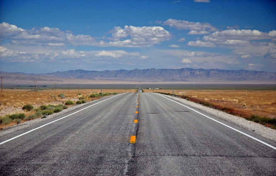
If anybody was to question me, I would have to deny any knowledge of the origins of the photograph below, and specifically deny that it could have possibly originated in the course of the trip depicted in the previous photo.

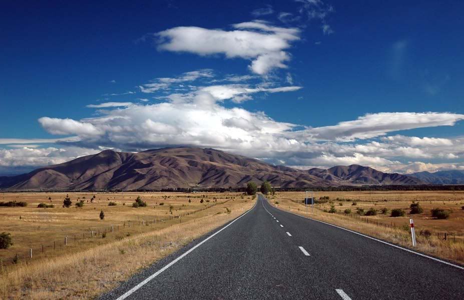
It is posted here for illustrative purposes only; to show that the purely hypothetical [ahem] scenario depicted below is feasible only north of the 50th parallel (and why I needed that 540hp 427).

Copy_of_RMA_June_2006_-_Enzo_Trip_Computer

Attachments

Images (1)
  • Copy_of_RMA_June_2006_-_Enzo_Trip_Computer
Last edited by George P
quote:
Originally posted by Peter H:
...you Americans can only use your Pantera to crawl along in endless stop-and-go traffic jams ...


No traffic jams in sight. While you're waiting for the snow to melt in the spring, or watching the snow falling in the Autumn, these are a small sampling of the roads I get to enjoy in sunny California. Spring and Autumn are my favorite driving seasons. The picture below is looking north along a stretch of Hwy 1 which is about 2 hours north of my home. That's the Pacific Ocean to the west....

125_2520-Hwy1

Attachments

Images (1)
  • 125_2520-Hwy1
Last edited by George P

I mention the dragon, because California has a stretch of road known as the Little Dragon. Hwy 49 is a long scenic highway that takes you through the heart of California's historic gold mining country, on the western slopes of the Sierra Nevada mountains. A 16 mile stretch of this highway, between Coulterville and Bear Valley, is the Little Dragon:

little_dragon

Attachments

Images (1)
  • little_dragon
Last edited by George P
I will come up someday Peter. I've never been to Charlie Lake. I'd love to hang out and sample the roads.

I have a request, I'd like that cute mounty to arrest me and take me back to her place for questioning.

HOw about the rest of you guys....I guess California, British Columbia and Hawaii are the only places with interesting roads.

Huh?
OK. I'm thinking. Carefully. And it only hurts a little bit... Yup, I still wish you would move to Calgary, Julian! Big Grin

Oh, and before I forget, I should clarify that many of the photos I posted on this thread were actually taken in Alberta and not just British Columbia as George assumed in his post above. The snow covered mountains in the photos are less than an hour's drive from Calgary.
Great Roads-Figueroa Mountain Road out of Solvang, don't hit Michael Jackson.
My firend Roland drove this road the other day.
Tail of the Dragon, follow the link. http://video.google.com/videoplay?docid=-3260006377844624494
I know it is the "F" Cars but wow what a road. He is the driver of the onboard footage. An F40 LM spec. It is the car in the Mothers ads. He said it was a great drive. A little more sedate would be any stretch of road on the Blue Ridge Parkway.
Last edited by George P
The road up and over Mount Tam, Marin County, CA. That is why you see so many car commercials there. The road from I-5 up to the Mount St. Helens viewpoint. Wide sweepers...
I have a list of roads outside Petaluma, CA also, I need to find it. I have a Montana list somewhere also.
Anyone headed to the Fun Rally going East on Hwy 40? Here's a fun little side trip you might want to try!


This little loop of old Route 66 goes through Oatman, AZ and covers about 60 miles. After passing through Needles you will cross the Colorado River, the drive begins at Exit 1, ending at Exit 44 and will give you a good workout. As one leaves Hwy 40, its under the rail bed, past Catfish Paradise the through Golden Shores (stay on the Oatman Hwy) - keep the speed within the law until you leave Golden Shores as we don't want anyone "detained" during the journey!

The road north is faily open and tempting, one might reach speed of 70mph or so but BEWARE! This piece of road has a few surprises in the form of a few 20mph dipsy-doodle S-curves that can be a nasty surprise.


The road will tighten somewhat when Oatman draws near,


until beautiful downtown Oatman closes in.


Oatman: craft shops, a hotel and restaurant and wonderful wild inhabitants that will eat right out of your hand should one be be so inclined (Wild Burro food is available in some shops). I happened upon these samples of local wildlife during a meeting of the Registry and the Ice Driving School Instructors.


I wouldn't park too close, nor corner them, who knows what might happen?

After Oatman, the road continues to climb to Sitgreaves Pass (Elev 3550) through many little curves and switchbacks.


Let me warn the traveler again: this road is not one where the driver wants to explore the limits of adhesion! When the road isn't bordered by rock walls and excursion into the scenery will start with a long fall. It looks like most of this will buff right out,


but still not something for your pride and joy to suffer!

Once over the pass, the road winds, dives, curls around down and through the rocks and ravines


to the gift shop and comfort station at the mouth of the canyon.


Here you can find t-shirts, curios, ice cream and plenty of parking while you stretch your legs. Don't let the crabby old bastard get to you, he's harmless!

These last few miles of straight road are filled with dangers - old hippies walking poodles, side traffic and a very BIG Angus bull that will stand in the road, in a dip, while you wait. Maybe not something to run into on your way to the freeway?

A few miles of whoop-de-dos and carefully following the signs will get you to Exit 44, just a few miles out of Kingman. Cheapest gas (by a dollar?) was at the Safeway store, try Hulapai Mountain Road, Exit 51.

Last edited by George P

Went out this past Sunday with a friend, his 1996 NSX and about a dozen of his friends in assorted 911s, Mazda Rx7, and a few others.  We had a great run through Topanga up Fernwood to Tuna Canyon, down to Pacific Coast Highway, and then up through Decker and Latigo Canyons.  Great drive except for a late '70's Porsche Targa which locked up its brakes on a sharp curve sending the driver across the road into a barrier which damaged his car pretty good.  Fortunately with a little help bending his fender back, he could drive it home.  Otherwise a great day.

20200517_073422

6370

20200517_073417

Attachments

Images (3)
  • 20200517_073422
  • 6370
  • 20200517_073417
Last edited by George P

Add Reply

Post
×
×
×
×
Link copied to your clipboard.
×